Notice
CLICK HERE for Online Permit Application
RLWD Ditch 17 (Proj. 179) - Detailed Findings and Order
Turtle Cross Connection Engineers Report
Turtle Cross Connection Hearing Location Map
Turtle Cross Connection Hearing Notice
News & Events
June 12th, RLWD Board Meeting @ 9:00 AM
June 26th, RLWD Board Meeting @ 9:00 AM
Select the link above to view the petition submitted to BWSR by Red Lake Watershed District and Sand Hill River Watershed District to change Watershed District Boundaries.
Monday-Thursday: 7:00AM-4:30PM
Friday: 8:00AM to 12:00PM
Saturday-Sunday: Closed
Videos
RLWD Maps
NEW DOCUMENTS
Project Spotlight
The Red Lake Watershed District is happy to report the installation of a monitoring buoy in Pine Lake. The buoy was purchased from Winter Recreation Technologies to help monitor lake levels and temperature. The data that the device collects is sent to a website (link provided) where it can be accessed almost anywhere! If you would like to access the information, please select the Pine Lake Buoy Data Link heading underneath the Notices section of the home screen.
Red Lake Watershed District
The Red Lake Watershed District is the regional governmental unit responsible for managing and protecting the water resources of the Red Lake River watershed, 5,990 square miles that includes all or part of ten Minnesota counties. The District was established in 1970 under the Minnesota Watershed District Act, Minnesota State Statutes Chapter 103D.
For more information about the history of the Red Lake Watershed District click here.
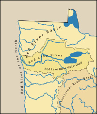
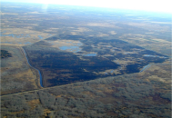
RLWD Subwatersheds
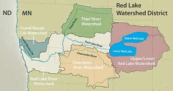
The jurisdiction of the Red Lake Watershed District includes land that flows into the Red Lake River and Grand Marais Creek. The map highlights the area that is encompassed by the Red Lake Watershed District and how the drainage area of the district is split into five major subwatersheds: Upper/Lower Red Lakes, Thief River, Clearwater River, Red Lake River, and Grand Marais Creek. Learn about the watershed you live in by clicking here and exploring the pages that were developed for each major subwatershed located within the RLWD. Each link will take you to a comprehensive compilation of information about each subwatershed including reports and photos.
RLWD Current Project Work Teams
Red Lake Watershed district currently has three active project work teams; the Mud River Improvement Project,
Turtle Cross Connection, and State Ditch 83.
For more information about the Mud River Improvement Project click here.
Engineering Projects
Red Lake Watershed District projects are designed to address specific problems within the Red Lake Watershed and to implement strategies and policies approved and set forth by the Board of Managers.
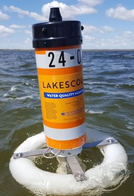
RLWD Water Quality Program
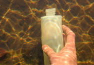
The Red Lake Watershed District Water Quality Program is a regional and statewide leader in establishing quality control standards for sample collection and data management. In coordination with other agencies, it also participates in numerous investigative studies, training programs, and public education events. Click here for a PDF of the Red River Basin Standard Operating Procedures.
RLWD Facilities
The Watershed District office building is located at 1000 Pennington Avenue South in Thief River Falls, Minnesota, 56701. Our phone number is 218-681-5800.