Moose River Impoundment - Project 13
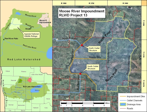
Project Location
The Moose River Impoundment is located at the headwaters of the Moose and Mud Rivers in northwestern Beltrami County, about 15 miles northeast of Grygla, MN. The drainage area of this impoundment is approximately 125 square miles.
Design Considerations
This impoundment facility was designed primarily for flood control and wildlife management. A freeboard flood storage capacity of 54,500 acre-feet helps to reduce peak flows on the Thief River and the Red Lake River during major runoff events, and enhances wildlife and associated recreational benefits at the site by retaining summer water in its north and south pools. Additional benefits include the ability to adjust and maintain normal downstream flows and to provide access to water for fire fighting.
Project Cost
The total project cost was approximately $3.4 million by the time the project was operational in 1988. Funding shares are approximately:
Contributor |
Total (1988 dollars)
|
|---|---|
| State of Minnesota | $1,690,000 |
| Red Lake Watershed District | $612,000 |
| Red River Watershed Management Board | $1,126,000 |
| TOTAL | $3,428,000 |
Moose River Impoundment - North Pool
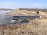
Gated Outlet Structure - North Pool
The North Pool flows into the Moose River (Judicial Ditch 21). The major components of the North Pool include 5 miles of diversion ditch, 4 miles of earthen dike (1218.0 msl), a gated outlet structure, and a rock-lined emergency spillway (1216.0 msl). Approximately one-third (41.7 sq. mi.) of the total project drainage area flows into the Moose River.
Moose River Impoundment - South Pool
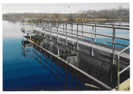
Gated Outlet Structure - South Pool
The South Pool flows into the Mud River (Judicial Ditch 11). The major components of the South Pool include 3 miles of diversion ditch, 9 miles of earthen dike (1220.0 msl), 4 miles of earthen dike between the North and South Pools, a gated outlet structure, and two emergency spillways (both at 1218.0 msl). An inter-pool structure was also built into the Division Dike to pass water between the North and South Pools. Approximately two-thirds (83.3 sq. mi.) of the total project drainage area flows into the Mud River.
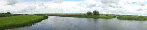
South Pool, looking northwest from the Gated Outlet Structure - June, 2008
Functional Design Data
Feature |
North Pool |
South Pool |
Total |
|---|---|---|---|
| Top of Dam Elev. | 1218.0 (ft. msl) | 1220.0 (ft. msl) | -- |
| Freeboard Flood Elev. | 1217.2 (ft. msl) | 1219.3 (ft. msl) | -- |
| Freeboard Flood Storage | 16,250 (acre-ft.) | 38,250 (acre-ft.) | 54,500 (acre-ft.) |
| Emer. Spillway Elev. | 1216.0 (ft. msl) | 1218.0 (ft. msl) | -- |
| Emer. Spillway Storage | 12,000 (acre-ft.) | 24,250 (acre-ft.) | 36,250 (acre-ft.) |
| Gated Pool Elev. | 1215.3 (ft. msl) | 1217.4 (ft. msl) | -- |
| Gated Pool Storage | 9,750 (acre-ft.) | 19,750 (acre-ft.) | 29,500 (acre-ft.) |
| Typical Summer Elev. | 1211.7 (ft. msl) | 1213.6 (ft. msl) | -- |
| Typical Summer Storage | 2,000 (acre-ft.) | 4,000 (acre-ft.) | 6,000 (acre-ft.) |
| Typical Winter Elev. | 1210.5 (ft. msl) | 1212.4 (ft. msl) | -- |
| Typical Winter Storage | 800 (acre-ft.) | 1,800 (acre-ft.) | 2,600 (acre-ft.) |
| Max No-Flood Elev. | 1212.5 (ft. msl) | 1214.5 (ft. msl) | -- |
| Max No-Flood Storage | 3,000 (acre-ft.) | 6,000 (acre-ft.) | 9,000 (acre-ft.) |
| Project Drainage Area | 41.7 (sq. mi.) | 83.3 (sq. mi.) | 125.0 (sq. mi.) |