Lost River Impoundment - Project 17
Project Location
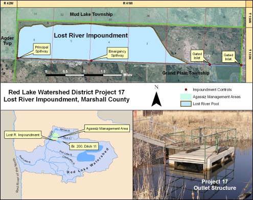
The Lost River Impoundment, Project 17, is located in Grand Plain Township of Marshall County, approximately 20 miles northeast of Thief River Falls. The 53.3 square mile drainage area above the impoundment structure consists primarily of flat agricultural terrain. The runoff from this area flows into Branch 200 of Ditch 11, and, depending on conditions, either flows into the Lost River Impoundment or continues downstream towards the Thief River.
Design Considerations
The Lost River Impoundment is a multi-purpose facility designed to increase wildlife values and reduce peak flows downstream by storing excess runoff. This "off-channel" design consists of approximately 10 miles of earthen embankment, an outlet control structure, an emergency spillway into Branch 200, and four 48-inch gated inlet culverts.
Project Operation
When the water flowing in Branch 200 reaches a critical elevation, excess flow is diverted into the impoundment through the inlet culverts and spillway. The minimum critical elevation, normally 1146.2 ft. msl, is controlled at the principle spillway.
The normal reservoir level (1146.2 ft. msl) is established with inflow through the gated inlet pipes. During periods of heavy runoff, when the water elevation in Branch 200 exceeds the highest spillway level (1148.2 ft. msl), it will flow over the inlet spillway into the inlet ditch. This flow will continue until the impoundment level reaches the same flow elevation as that in the Branch 200 channel.
Functional Design Data
Feature |
Measurement |
Storage |
|---|---|---|
| Top of Dam | 1150.2 (ft. msl) | 14,600 (acre-ft.) |
| Emergency Spillway | 1148.2 (ft. msl) | 10,000 (acre-ft.) |
| Normal Summer Level | 1146.2 (ft. msl) | 5,500 (acre-ft.) |
| Normal Winter Level | 1145.2 (ft. msl) | 3,700 (acre-ft.) |
| Drainage Area | 53.3 Sq. Mi. | -- |
The Lost River Impoundment was originally funded and built in the mid 1970's by the Minnesota Department of Natural Resources. In 1978, the Red Lake Watershed District and the Department of Natural Resources agreed to modify the impoundment by raising the dike and spillway elevations, and extend the inlet channel. These modifications were designed to raise the normal pond elevation to provide more suitable habitat for waterfowl and to further lessen peak flooding in downstream areas. The cost of modification, in 1979 dollars, was approximately $109,000.