Elm Lake-Farmes Pool - Project 52
Project Location
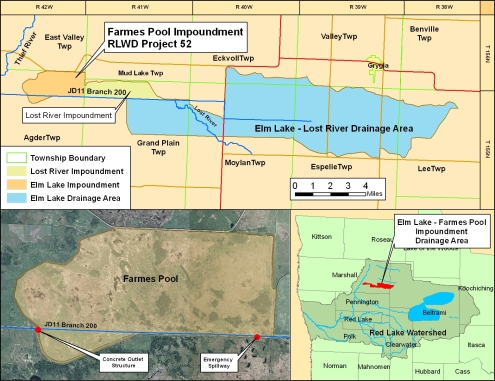
The Elm Lake-Farmes Pool Project (RLWD Project 52) is located in Marshall County, about 17 miles northeast of Thief River Falls. The drainage area of Judicial Ditch 11 Branch 200, upstream from Elm Lake, is 63 square miles.
Design Considerations
The Elm Lake-Farms Pool Project is designed to accomplish three main objectives: to provide a means of flood control in downstream areas, to improve the value of the area as wildlife habitat, and to improve the drainage in upstream areas.
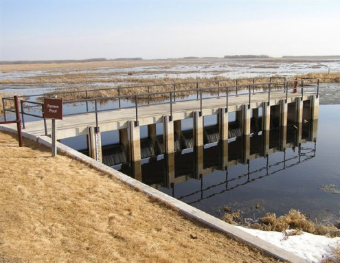
Stoplog Outlet Structure
The Elm Lake-Farms Pool Project became operational in 1991. It was a cooperative effort between the U.S. Fish and Wildlife Service, the Minnesota Department of Natural Resources, the Red Lake Watershed District, and Ducks Unlimited, with majority of the fuding provided by Ducks Unlimited. At the time of construction, the Elm Lake-Farms Pool Project was the largest Ducks Unlimited project in the lower 48 states.
Project Components
The project consists of approximately nine miles of earthen embankment, an outlet control structure at the southwest end, a rock-lined emergency spillway at the southeast end, and an enlargement of a portion of Branch 200 that feeds into the Lost River impoundment, upstream of the Project 52 structure.
Functional Design Data
Feature |
Measurement |
Storage |
|---|---|---|
| Top of Dam | 1145.0 (ft. msl) | 19,700 (acre-ft.) |
| Emergency Spillway | 1142.0 (ft. msl) | 11,000 (acre-ft.) |
| Max Summer | 1141.0 (ft. msl) | 7,500 (acre-ft.) |
| Typical Summer | 1140.0 (ft. msl) | 5,500 (acre-ft.) |
| Typical Winter | 1139.0 (ft. msl) | 3,500 (acre-ft.) |
| Drainage Area | 63.0 (sq. mi.) | -- |